Mallorca Map: Beaches, Hidden Corners, Driving Distances & Local Tips
Looking for a Mallorca map that’s actually useful? Most maps of Mallorca (or Majorca) only show roads, towns and tourist attractions. At Click Mallorca, we wanted to create something different: a collection of unique Mallorca maps designed by local experts who know the island first-hand after years of exploring its beaches, mountain roads, villages and hidden corners.
In this guide, you’ll find much more than a basic map of Mallorca. We’ve created visual maps showing the best beaches, the most crowded tourist areas, hidden corners known mostly by locals, realistic driving distances and the best areas to stay depending on the type of holiday you want.
Every map in this guide is based on local experience, real travel knowledge and practical advice gathered from helping thousands of visitors discover Mallorca every year. Whether you are planning your first trip to Mallorca or returning to explore more of the island, these maps will help you experience the island smarter, easier and more like a local.
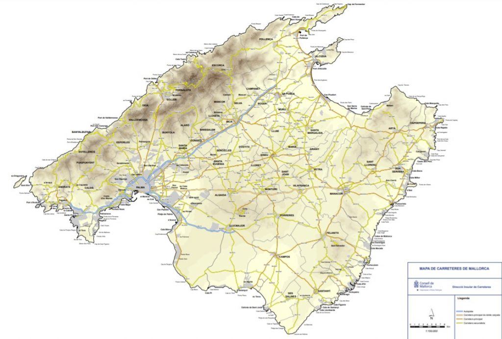
Basic Mallorca Map: Understanding the Island at a Glance
Mallorca is the largest of Spain’s Balearic Islands and is located in the western Mediterranean Sea, east of mainland Spain. Although many people search for “Majorca map” in English, Mallorca and Majorca refer to the same island. Understanding the basic geography of Mallorca is essential before deciding where to stay, which beaches to visit or how to plan your itinerary.
Palma de Mallorca, the island’s capital, is located in the southwest and is also home to the main airport. From here, most visitors explore different parts of the island depending on what they are looking for: the mountains of the northwest, the family-friendly beaches in the north, the hidden coves of the southeast or the quieter rural villages in the centre of Mallorca.
One of the things many travellers underestimate when looking at a Mallorca map is the diversity of the island. Mallorca may seem small on the map, but each area offers a completely different experience. The northwest is dominated by the dramatic Serra de Tramuntana mountain range, while the south and east are known for turquoise-water beaches and calas. Northern Mallorca is especially popular with families and beach lovers, while Palma combines city life, history, shopping and nightlife.
If you are looking for detailed information about where Mallorca is located in Europe, distances from mainland Spain and how to find Mallorca on the map, we recommend reading our full guide: Where is Mallorca (Majorca) on the Map?
Mallorca Beaches Map: The Best Beaches and Calas Around the Island
Mallorca is famous for its coastline, but one of the biggest mistakes visitors make is assuming that all beaches in Mallorca are similar. In reality, every area of the island offers a completely different beach experience. Some beaches are long and family-friendly with easy access and shallow water, while others are small hidden calas surrounded by cliffs and pine forests.
At Click Mallorca, we have explored beaches all around the island for years, and this Mallorca beaches map is designed to help travellers quickly understand which areas are best depending on the type of beach experience they are looking for.
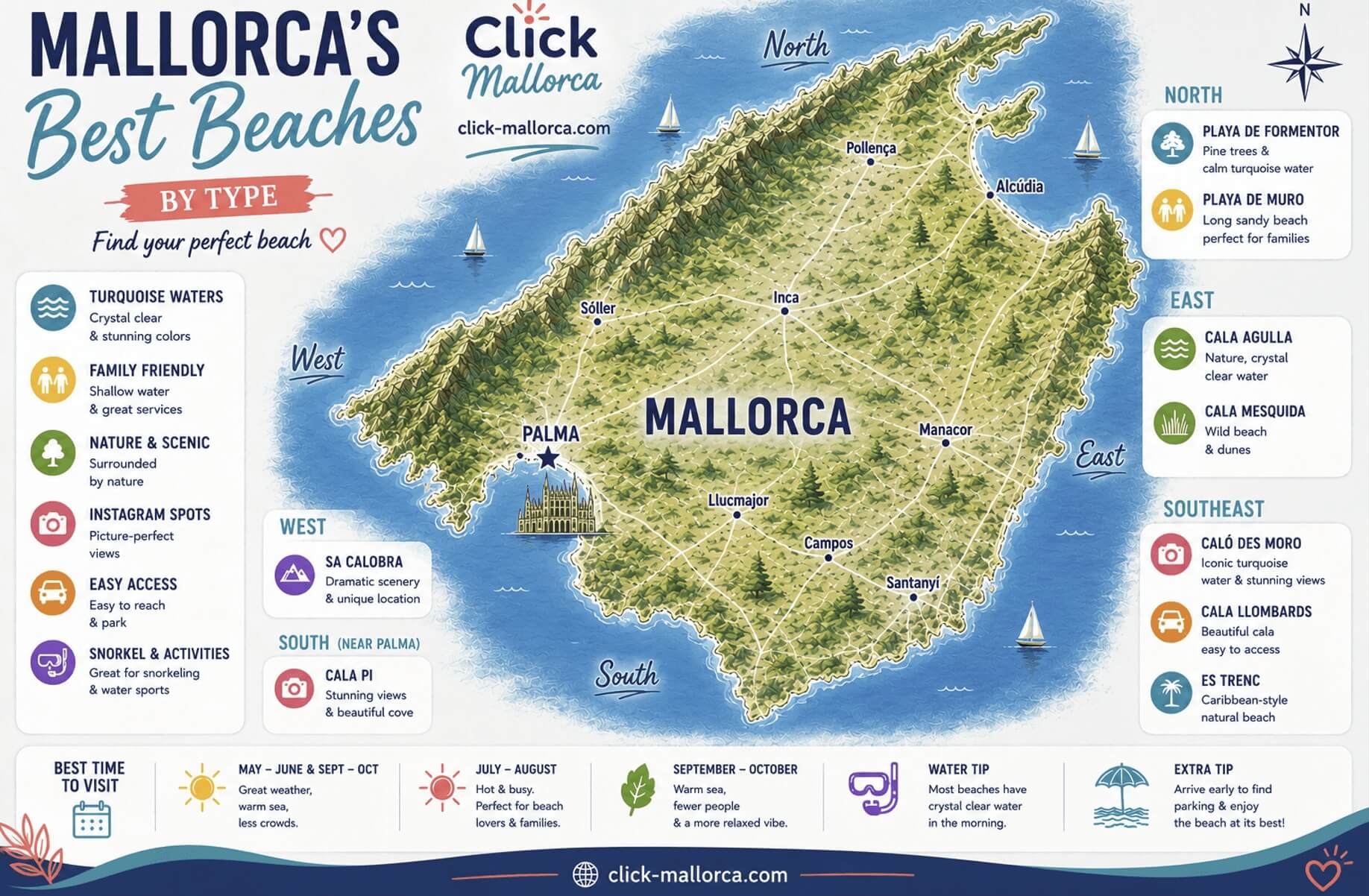
In the north of Mallorca, beaches such as Playa de Muro and Playa de Formentor are known for calm water, soft sand and family-friendly conditions. These are some of the best beaches in Mallorca for travellers with children or visitors looking for easy access and long sandy beaches.
The southeast of Mallorca is home to some of the island’s most famous calas, including Caló des Moro and Cala Llombards. This area is especially popular for turquoise water, dramatic scenery and Instagram-famous beaches, although many calas here become extremely crowded during summer.
On the eastern coast, beaches such as Cala Agulla and Cala Mesquida offer a more natural setting with dunes, pine forests and crystal-clear water. Meanwhile, iconic beaches like Es Trenc are famous for their Caribbean-style scenery and long stretches of white sand.
This map was created not only to show where Mallorca’s best beaches are located, but also to help travellers choose the right beaches based on accessibility, scenery, atmosphere and local experience.
Mallorca Crowds Map: the busiest tourist spots on the island
This illustrated Mallorca map shows some of the most crowded places in Mallorca during the high season. From the traffic jams of Sa Calobra and Cap de Formentor to the packed streets of Sóller and the cruise ship crowds in Palma de Mallorca, the map helps visitors understand where tourism pressure is highest in summer.
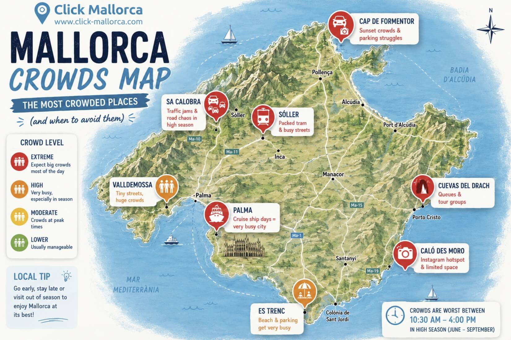
It also highlights extremely popular attractions such as Cuevas del Drach, Caló des Moro and Es Trenc, where parking, queues and overcrowding are common between June and September.
Despite the crowds, these places are still worth visiting if you plan your visit carefully. The best strategy is usually to arrive early in the morning, visit outside peak summer months, or stay later in the afternoon when most organized groups have already left.
This map is designed to help travelers enjoy Mallorca more comfortably while also understanding the reality of tourism on the island during high season.
Mallorca Hidden Corners Map: Authentic Places Beyond the Tourist Hotspots
Mallorca is much more than crowded beaches and famous tourist attractions. Beyond the busy resorts and the most photographed places, the island still hides authentic villages, peaceful mountain roads, hidden coves and local experiences that many visitors never discover.
At Click Mallorca, we spend the whole year exploring the island, and this Mallorca Hidden Corners Map was created to share some of the places that still feel authentic, local and different from the typical tourist routes.
Unlike many generic travel maps, this guide focuses on places that offer a more genuine side of Mallorca. Some are quiet mountain villages, others are hidden beaches or lesser-known attractions where you can still experience the island at a slower pace.
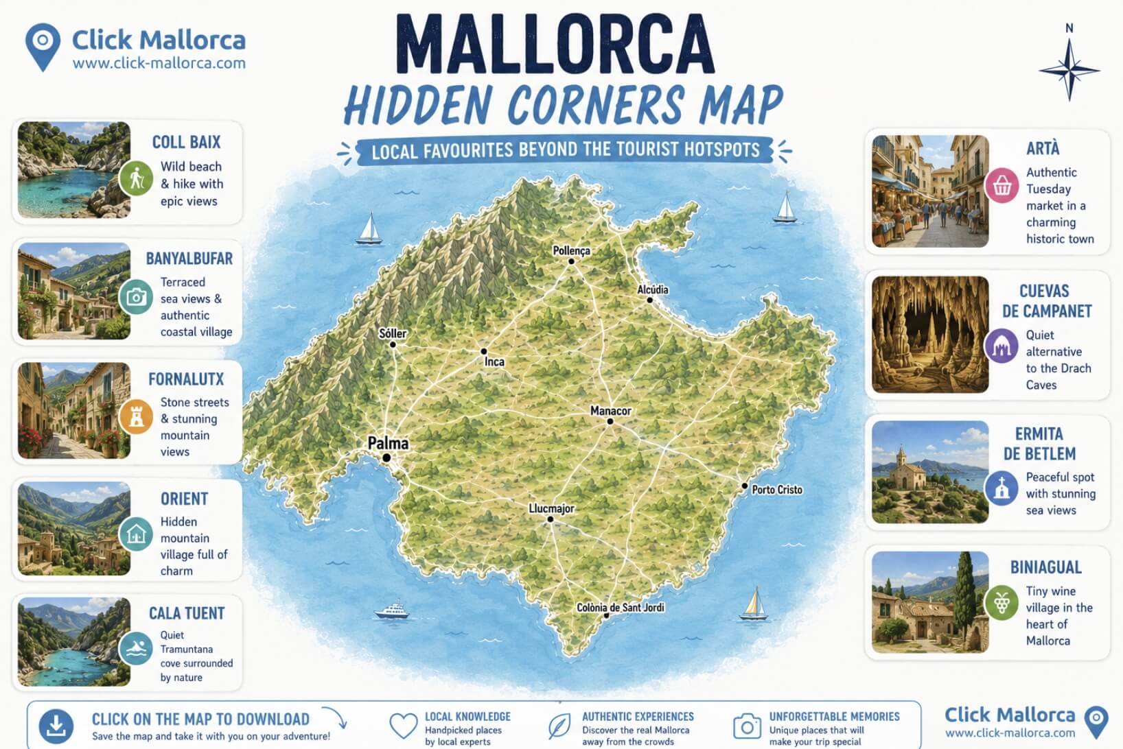
In the Tramuntana mountains, places such as Fornalutx, Orient and Banyalbufar are perfect examples of traditional Mallorca, with stone houses, mountain scenery and spectacular views far from the larger tourist crowds.
Nature lovers will find unique spots like Coll Baix and Cala Tuent, two beautiful coastal areas that still preserve a wild and untouched feeling compared to many of Mallorca’s more famous beaches.
For travellers interested in culture and local life, Artà offers one of the island’s most authentic weekly markets every Tuesday, while tiny villages like Biniagual show a quieter and more traditional side of inland Mallorca.
The map also includes places like Cuevas de Campanet and Ermita de Betlem, which are ideal for travellers looking for peaceful experiences, scenic landscapes and places that many tourists overlook.
This map is designed for curious travellers who want to explore Mallorca beyond the obvious and discover the island through local knowledge and real first-hand experience.
Mallorca Best Excursions Map: Unforgettable Experiences Around the Island
Mallorca is much more than beaches. One of the best ways to truly experience the island is through excursions that combine nature, local culture, scenic landscapes and unforgettable activities. At Click Mallorca, we have spent years helping travellers discover the best experiences across the island, and this Mallorca Best Excursions Map brings together some of the tours and activities visitors enjoy the most.
Unlike generic Mallorca travel guides, this map was created by local experts who know Mallorca first-hand and understand which excursions truly offer memorable experiences. From boat trips and mountain routes to cultural visits and scenic train rides, these are activities that help travellers experience different sides of Mallorca.
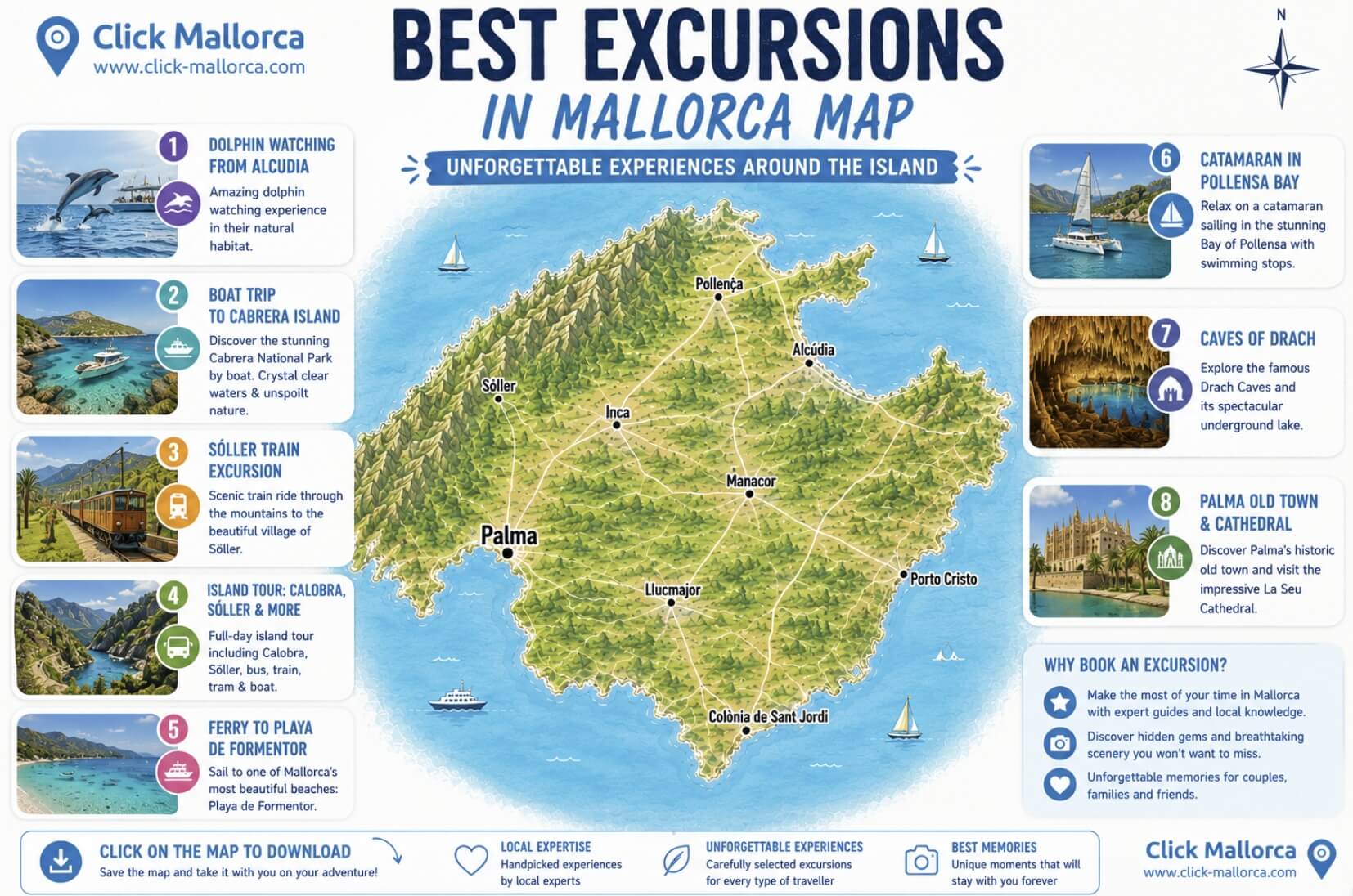
In the north of the island, experiences such as dolphin watching in the Bay of Alcudia and catamaran cruises in Pollensa Bay are among the most popular boat excursions in Mallorca. For visitors looking for iconic landscapes, the Island Tour combining Sa Calobra, Sóller, boat, tram and train remains one of the most complete ways to explore the Serra de Tramuntana.
One of Mallorca’s most famous experiences is the historic Sóller train excursion, which crosses mountains, tunnels and orange groves before arriving in one of the island’s most beautiful villages. Visitors looking for beaches and coastal scenery often choose the ferry excursion to Playa de Formentor or boat trips to the protected island of Cabrera National Park.
The map also includes some of Mallorca’s top cultural and sightseeing experiences, including visits to Cuevas del Drach and guided tours through the historic centre of Palma de Mallorca and its impressive cathedral.
Every excursion featured on this map was selected based on real local experience, traveller feedback and years of helping visitors discover the best of Mallorca beyond the typical tourist routes.
Mallorca Driving Distances Map: Real Driving Times Around the Island
One of the biggest mistakes travellers make when planning a Mallorca road trip is underestimating driving times. Although Mallorca may look small on the map, mountain roads, coastal routes and summer traffic can make journeys much longer than expected.
At Click Mallorca, we help thousands of visitors explore the island every year, and this Mallorca Driving Distances Map was created using real local driving experience — not just theoretical distances. The goal is to help travellers better understand how long it actually takes to move around Mallorca by car.
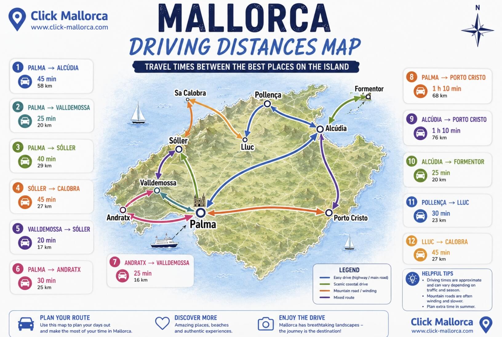
This map includes some of the island’s most popular routes, such as driving from Palma de Mallorca to Alcúdia, from Palma to Sóller, or scenic mountain drives like the spectacular road between Sóller and Sa Calobra.
The map also highlights routes many travellers combine during road trips, including:
- Valldemossa to Sóller
- Palma to Andratx
- Pollença to Lluc Monastery
- Lluc to Sa Calobra
- Alcudia to Cap de Formentor
- Palma to Porto Cristo
One of the most important things visitors should understand is that driving in Mallorca is very different depending on the area. Routes across the centre of the island are generally fast and easy, while roads in the Serra de Tramuntana involve curves, narrow sections and slower speeds. During summer, parking and traffic near popular places such as Formentor, Sa Calobra or Sóller can also increase travel times significantly.
This map was designed to help travellers plan more realistic itineraries, avoid spending too much time driving and enjoy Mallorca at a more relaxed pace.
Mallorca Where to Stay Map: Best Areas for Every Type of Traveller
Choosing where to stay in Mallorca can completely change your holiday experience. Although the island may seem small on the map, each area of Mallorca offers a very different atmosphere, landscape and style of travel. Some areas are perfect for families and beach holidays, while others are better for nightlife, cycling, romantic escapes or travellers without a car.
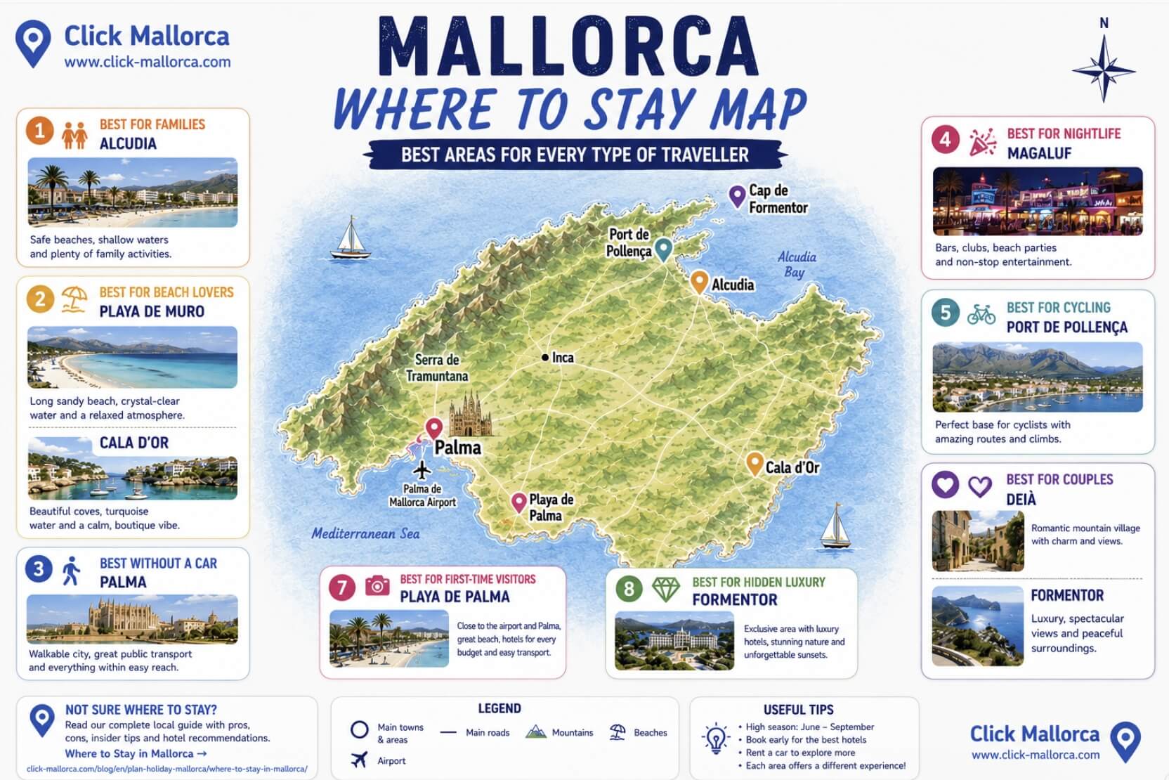
For families, areas such as Alcúdia and Playa de Muro are among the most popular choices thanks to their safe beaches, calm waters and family-friendly atmosphere. Travellers looking for beautiful coves and a more relaxed beach vibe often prefer Cala d’Or.
Visitors who prefer not to rent a car usually find Palma de Mallorca the most convenient place to stay, thanks to its walkable old town, public transport connections, restaurants and cultural attractions. For first-time visitors wanting a mix of beach and city access, Playa de Palma is also a popular option.
Mallorca is also one of Europe’s top destinations for cycling holidays, and areas such as Port de Pollença are especially popular among cyclists thanks to easy access to the Serra de Tramuntana mountain routes.
For couples and travellers looking for a more romantic or scenic atmosphere, places such as Deià and Cap de Formentor offer spectacular landscapes, peaceful surroundings and some of Mallorca’s most iconic views.
Meanwhile, travellers looking for nightlife and entertainment often choose Magaluf, known for its lively bars, beach clubs and party atmosphere.
This map was created to help travellers quickly understand the different personalities of Mallorca’s main resort areas and choose the best base for their holiday style.
More Unique Mallorca Maps Coming Soon
At Click Mallorca, we are constantly creating new Mallorca maps designed to help travellers explore the island in a more practical, authentic and visual way. Our goal is simple: to combine local knowledge, first-hand experience and modern creative visual tools to create maps that tourists actually find useful.
These maps are based on years of exploring Mallorca, helping travellers daily and continuously updating our local knowledge of the island. We would love to continue expanding this collection with new ideas, road trips, hidden beaches, family areas, scenic drives, hiking routes and many more Mallorca maps.
If there is a specific Mallorca map you would like us to create, feel free to leave a comment or contact us directly via WhatsApp — we always love hearing ideas from travellers exploring the island.
Frequently Asked Questions About Mallorca Maps
Mallorca is located in the western Mediterranean Sea and belongs to Spain’s Balearic Islands. The island is east of mainland Spain, close to cities such as Barcelona and Valencia. Palma de Mallorca is the capital and main transport hub of the island.
Yes. Mallorca and Majorca are the same island. “Mallorca” is the Spanish and Catalan spelling, while “Majorca” is the traditional English spelling. Both terms are commonly searched online.
The best area depends on the type of holiday you want. Families often choose Alcudia or Playa de Muro, couples prefer Deià or Formentor, nightlife travellers stay in Magaluf, and visitors without a car usually choose Palma.
The north and southeast of Mallorca are especially famous for beaches and calas. Playa de Muro, Formentor, Cala Agulla, Caló des Moro and Es Trenc are among the island’s most popular beach areas.
Yes, Mallorca is one of the best destinations in Spain for road trips. However, many visitors underestimate driving times in the mountains and coastal roads, especially in the Serra de Tramuntana area.
Driving across Mallorca from Palma to Alcudia usually takes around 45 minutes, while routes through the mountains can take much longer due to curves and scenic roads. A full road trip around the island normally requires several days to enjoy properly.
During summer, places such as Sa Calobra, Cap de Formentor, Palma old town, Cuevas del Drach and Caló des Moro can become extremely crowded, especially between June and September.
Yes. Although Mallorca is a very popular destination, there are still authentic villages, hidden coves and quieter areas away from the main tourist hotspots. Places such as Orient, Biniagual, Cala Tuent and Ermita de Betlem are good examples.
Some of the most popular excursions in Mallorca include dolphin watching in Alcudia, the Sóller train trip, the Island Tour with Sa Calobra, boat trips to Cabrera and visits to the Drach Caves.
The best activities to enjoy the island: Excursions in Mallorca
Wide choice of hotels with flexible cancellation and the best prices: Hotels in Mallorca
Rent a car in Mallorca at the best prices. Rent a car in Mallorca
Find flights to Mallorca at the best prices: Flights to Mallorca
Boat trips and catamaran tours: Boat trips in Mallorca
More Info about Mallorca: Mallorca Travel Blog